Weather
Last update: 02.08.2026, 10:00
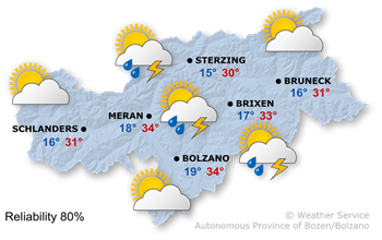
Today's weather
High air pressure and unstable air masses are shaping the weather in South Tyrol.
After a very sunny morning, large cumulus clouds will form, leading to isolated thunderstorms.
The highest temperatures range from 27° to 34°.
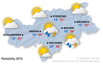
Tomorrow's weather
A high-pressure system, combined with subtropical air masses, is set to bring another hot summer’s day.
It will be very sunny this morning, with any remaining morning clouds clearing quickly. In the afternoon some isolated thunderstorms.
Maximum temperatures are rising slightly again, reaching 28° in the upper Puster Valley and up to 36° in the lowlands.
Further development

36°/14°
Tuesday, 04.08
37°/14°
Wednesday, 05.08

36°/14°
Thursday, 06.08
33°/14°
Friday, 07.08
On Tuesday morning, there will be bright sunshine; in the afternoon, isolated thunderstorms will develop again, but it will mostly remain dry.
Wednesday will also bring plenty of sunshine in the morning, but even afterwards, only isolated thunderstorms are expected.
On Thursday, the sunshine will continue, though thunderstorms will become more frequent in the afternoon.
Friday will bring a mix of sunshine, clouds and a few thunderstorms.
Today's mountain weather
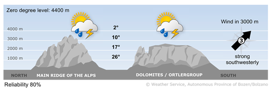
Sunshine and a few thunderstorms
In the early morning and during the morning, clouds may reduce visibility in some areas, and the first thunderstorms are possible. A few heat-related thunderstorms are expected during the afternoon.
High wind
2 - moderate wind
16-30 km/h
3 - strong wind
31-60 km/h
Tomorrow's mountain weather
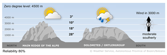
Sunny and warm
Conditions will be good in the morning, but watch out for localised thunderstorms in the afternoon and evening.
High wind
2 - moderate wind
16-30 km/h
3 - strong wind
31-60 km/h