Weather
Last update: 31.07.2026, 11:00
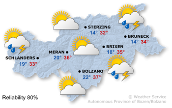
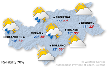
Today's weather
With the upper-level flow the atmospheric stratification will becoming less stable.
In the coming hours, cumulonimbus clouds will become increasingly common, and localised thunderstorms are expected shortly. These may be severe.
Very hot again, with maximum temperatures of 33° in the Wipptal valley and 37° in the Bolzano area.
Tomorrow's weather
The air masses are very warm, and the atmosphere remains unstable.
The morning will be generally fine, although residual clouds from overnight showers may lead to variable cloud cover in some areas; furthermore, isolated thunderstorms cannot be entirely ruled out. With cumulus clouds building up in the afternoon, heat-induced thunderstorms are likely. A northerly foehn wind will pick up in some valleys.
The maximum temperatures are well above average, reaching 27° in Sterzing, where the Föhn is blowing, and 36° in Bolzano.
Further development

35°/13°
Sunday, 02.08

35°/14°
Monday, 03.08
35°/14°
Tuesday, 04.08

36°/14°
Wednesday, 05.08
Sunday will bring high-summer conditions with sunshine and localised thunderstorms in the afternoon.
On Monday morning, there will be glorious sunshine, but a few thunderstorms will develop again in the afternoon.
Tuesday will also bring plenty of sunshine in the morning, after which thunderstorms are likely again.
Wednesday will bring plenty of sunshine, with only a slight increase in the likelihood of thunderstorms in the afternoon.
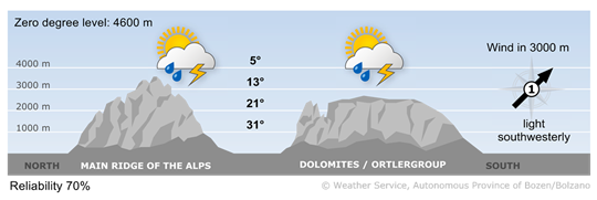
Today's mountain weather

Very good mountain weather this morning
The morning is characterised by excellent visibility and largely cloudless skies. As the sun comes out, cumulus clouds will begin to form more frequently, and the risk of thunderstorms will rise rapidly from midday onwards.
High wind
2 - moderate wind
16-30 km/h
3 - strong wind
31-60 km/h
Tomorrow's mountain weather
Thunderstorms again this afternoon
The weather in the mountains will be fine in the early morning and during the morning, although the possibility of the first thunderstorms cannot be entirely ruled out. A few heat-related thunderstorms are expected during the afternoon.
High wind
2 - moderate wind
16-30 km/h
3 - strong wind
31-60 km/h